The first webinar, entirely in Italian, of the OCTO Smart Talks series held on April 23, was a huge success. The interactive style and the trend topics, addressed by Edwin M. Colella CMO of Octo Telematics, Fabio Pressi CEO of Infoblu and through the collaboration of the journalist Alessandro Palumbo, aroused great interest in the public present. Retrace and relive the emotions of our “Smart Talk”
Researcher David Mirynech from Blockchain
Research Institute published a white paper regarding how
blockchain technology will optimize the deployment of autonomous vehicles
(“Autonomous Vehicles and Blockchain, How a Distributed Ledger System could
fund the next generation of transportation infrastructure”, See the full report
here – https://www.blockchainresearchinstitute.org/ ).
Blockchain’s inherent ability to
communicate and issue, trade, and manage value in a secure and reliable way
makes it particularly appealing as the foundation for a new revolutionary kind
of transportation economy.
While blockchain has a demonstrable impact on tolling
systems (by reducing the need for heavy infrastructure), centralized servers
and databases, identity, and credit card systems, the researcher highlight that
it can also help to increase the profit functions of vehicles.
Chris Ballinger, the CEO of MOBI, said:
“Vehicles are now connected, and they are getting smarter. Those two things
allow vehicles to participate in the service economy in ways they never could
before.”
Owners can lease their own vehicles by utilizing
blockchain-based rider identity. As assets, self-driving cars can work constantly,
delivering value to owners around the clock with fees based on such factors as
time, distance, and weight or value of cargo.
Once in circulation, autonomous vehicles
become shared resources for rental, use, and insurance on demand.
Vehicle data could also be amended for lease.
To finance state and federal roadway
networks, governments could capture these revenues through instantaneous
remittances.
Vehicle owners or operators may one day
receive compensation for sharing other basic resources, such as renewable
energy and Internet connectivity.
Mobile
Open Blockchain Initiative
To understand how multiple stakeholders may benefit
and prepare for such technological change, large consortia such as MOBI (Mobile Open Blockchain Initiative) provide
examples of how we should approach innovation.
MOBI is replacing siloed and secretive
research and development (R&D) with collaboration among technology
developers, automotive manufacturers, transportation authorities, and other
stakeholders to provide a road map for overcoming barriers to adoption Ledger
System
MOBI’sfirst project aims
to develop an identity system, known as a “car passport,” for vehicles that
tracks mileage and all relevant data on the blockchain.
With vehicle identity figured out, the
author considers that insurance applications that run on the blockchain are
also a target for development. With an immutable data feed characterizing a
car’s history, insurance providers can apply a dynamic pricing model specific
to that vehicle pricing by the perceived riskiness of drivers or their vehicles
based on age, gender, make, or model.
This model is known as usage-based
mobility pricing.
The researcher understands that
blockchain could also reduce information asymmetries in used car markets,
improve accuracy and verifiability of insurance claims and automate claims
processing,
At Consensus 2017, MOBI debuted its blockchain-enabled
P2P car lease application. This application allows for consumers to lease the
vehicle from a car owner using a smart contract on the Ethereum blockchain,
file storage on IPFS, and a mobile application to lease and control access to
the vehicle.3
These applications allow for instantaneous remittance
between transacting parties and they are able to do so without the need for
payment processors by using logic coded to a smart contract.
In addition, by tokenizing the car’s identity, we
could enable private GPS and time-stamped data to the data exchange,
immediately allowing for route optimization and capacity modeling for other
entities to consume.
The researcher stress that this process is extremely
valuable because automobile owners are immediately able to monetize their
unused vehicle time to trusted drivers or riders. In preparation for the future
of autonomous vehicles, this platform enables users to pay and get mobility on
demand.
Communications
network latency: Telecommunications is critical. The need for high-frequency
data input is spurring the build out of national 5G networks. Demand for
blockchains that can support high user volumes is prompting advances in
scalability solutions such as state channels, side channels, sharing, and
interoperable chains.
While the race to bring autonomous
vehicles to market is intensifying, additional 5G network infrastructure is
required before these cars experience their highest performance and
functionality.
Immutable
records versus privacy: In the world of technology, no issue has been
more prevalent this year than data privacy.
Rising fears over the security of these data on a
growing number of interconnected devices is leading to the enforcement of
higher security standards, consumer education, and even further integration of
blockchain and connected IoT devices.
Legal
and ethical implications: although vehicle manufacturers have accepted liability
for accidents caused by software, the author acknowledges that the true legal
implications of a future with autonomous vehicles remain unknown. The law will
take the necessary time to come up with a proper legal framework. However,
considering how quickly this industry is emerging, regulators must keep pace
with innovation.
Governments at all levels must prepare for disruption.
Despite this progress, we must prepare for the consequences of technological
innovation.
Toyota Woven City: this is the name chosen for the prototype city of the future that the Japanese automaker is planning at the base of Mount Fuji in Japan.
It is a fully connected ecosystem powered by hydrogen fuel cells. Envisioned as a living laboratory, it will serve as a home for full-time residents and researchers who will be able to test and develop technologies such as robotics, personal mobility, smart homes and artificial intelligence.
“Building
a complete city from the ground up, even on a small scale like this, represents
a unique chance to develop future technologies, including a
digital operating system for the city’s infrastructure. With people, buildings
and vehicles all connected and communicating with each other through data and
sensors, we will be able to test connected artificial intelligent technology…
in both the virtual and the physical realms… maximizing its potential,” said
Akio Toyoda, president, Toyota Motor Corporation.
The
buildings will be made of wood to minimize CO2 emissions, the
rooftops will be covered in photovoltaic panels to generate solar power in
addition to power generated by hydrogen fuel cells.
The houses will be equipped with the latest home automation technologies to assist with daily living.
As far as the mobility of the city is concerned, there will be three road types: for faster vehicles, for lower speeds and for pedestrians only. These three road types weave together to form an organic grid pattern to help accelerate the testing of autonomy. To move residents through the city, only fully autonomous, zero emission vehicles will be allowed. In addition, Toyota autonomous e-Pallets will be used for transportation and deliveries.
For the design of Woven City, Toyota commissioned the Danish architect Bjarke Ingels, founder and creative director of the Bjarke Ingels Group, who designed many high-profile projects (Two World Trade Center in New York and the Lego House in Denmark, the California Google’s Mountain View and London headquarters. “A swarm of different technologies – says Ingels – is beginning to radically change the way we inhabit and live our cities. Connected, autonomous, emission-free and shared mobility solutions are bound to unleash a world of opportunities for new forms of urban life.”
Researchers Zuoxian Gan, Min Yang, Tao Feng and Harry Timmermans published an article on Springer Nature on 2018, regarding the urban mobility patterns.The article provides a up-to-date review on this issue. Here there are some of the key issues.
Smart card data derived from
automatic fare collection (AFC) systems of public transit enable us to study
resident movement from a macro perspective. The rhythms of traffic generated by
different land users differ, reflecting differences in human activity patterns.
Thus, an understanding of daily ridership and mobility patterns requires an
understanding of the relationship between daily ridership patterns and
characteristics of stations and their direct environment.
Unfortunately, few studies have
investigated this relationship. Researchers stress that this study aims to
propose a framework of identifying urban mobility patterns and urban dynamics
from a spatiotemporal perspective and pointing out the linkages between
mobility and land cover/land use (LCLU). Relying on 1 month’s transactions data
from the AFC system of Nanjing metro, the 110 metro stations are classified
into 7 clusters named as employment-oriented stations, residential-oriented
stations, spatial mismatched stations, etc., each characterized by a distinct
ridership pattern (combining boarding and alighting).
The analytical framework and
findings may be beneficial for improving service efficiency of public
transportation and urban planning. The authors consider that this study
presents one of the first attempts of exploring the relationship between local
LCLU and metro ridership patterns, while at the same time analyzing the layout
of urban functions in a Chinese city.
The emergence of information and
communication technologies (ICT) and the rise of big data have advanced
research on travel behavior, activity mining, mobility flows and mobility
regularities Big data with specific time–space information of travelers make it
possible to analyze urban mobility from a spatiotemporal perspective. Moreover,
the sample size of these datasets also improves the accuracy of the analysis.
Big travel data can be divided into GPS devices, taxi trajectories, mobile
phone data, smart card data (SCD) and social media data.
In contrast to taxi trajectories and social medial check-in data, the other three types of data have two salient advantages: high spatiotemporal precision and tracking long-term resident movements.
Study area and data collection
Nanjing, the heart of Nanjing Metropolitan, is the capital of Jiangsu Province and one of most important political, economic, and cultural centers in eastern China, known also by its famous historical and cultural richness. It covers a total of 6587.02 square kilometers.
The city represents the typical microcosm of Chinese cities, which are still under rapid population urbanization and urban growth. Its total population increased from 4.7 million in 1985 to 8.27 million in 2016 and the number of urban residents increased to 6.78 million, accounting for 82% increase. For the purpose of analysis, the dataset was first aggregated and converted into hourly records.
There were 21 weekdays, 8 weekends
and 1 holiday in April 2015. Researchers focused on people’s travel patterns on
weekday and the records of 9 non-weekdays were not considered.
In addition to the metro trip
dataset, the researchers also used the land use data of the Nanjing region from
the Nanjing Urban Planning Bureau (NUPB).
Discussion and conclusions
As the authors of the article
explain, the results show that, among these stations, the employment-oriented
stations and the mixed mainly employment-oriented stations have the highest
ratios of afternoon peak hourly boarding and morning peak hourly alighting.
Meanwhile, the residential-oriented stations and the mixed mainly residential-
oriented stations have the highest ratios of afternoon peak hourly alighting
and morning peak hourly boarding in weekdays.
The results of the multinomial logit model confirm that the spatial distribution of different types of metro stations reflects the spatial distribution of different urban functions.The researchers highlight that the results of the study may have some implications for Nanjing urban design and transit planning.
The implication of this finding may be important for transit operators to work out suitable train schedules to improve service efficiency. Moreover, these results may especially be useful for daily arrangements and services in metro stations, especially the connection between metro and other transportation modes. In terms of medium- and long-term planning, these results can help planners better understanding urban mobility.
The authors of the article acknowledge that the metro system
is a restricted representation of urban mobility although it carries a large
volume of passengers in a city and plays an important role in daily travel. The
approach needs to be extended certainly to other traffic modes such as bus,
tram etc. to enrich the analysis.
The integration of more transportation modes may be considered
more accurate to understand urban mobility patterns and the link between
mobility patterns and urban land use. Lastly, the conceptual framework proposed
in the present paper may be applied in other cities having rail transit
systems. Comparative and empirical studies across cities are encouraged in the
future.
Transportation Systems (ITS) aim to improve safety, mobility and environmental performance of road transport. The INSIGMA project provides a fresh look at the possible innovations in this field, by enhancing the functionality and accuracy of ITS in urban environments.
Researchers Wojciech Chmiel, Jacek Danda, Andrzej Dziech,
Sebastian Ernst, Piotr Kadluczka, Zbigniew Mikrut, Piotr Pavlik, Piotr Szved
and Igor Wojnicki published an article online on 26th May 2016, named INSIGMA:
an intelligent transportation system for urban mobility enhancement regarding
an intelligent transportation system. The article provides an a-up -to date
review on this issue. Here there are some of the key issues.
Modern Intelligent Transportation Systems (ITS) are a useful
and necessary tool made to help battle traffic congestion. Among other
advantages, it is expected that dynamic traffic control and vehicle navigation
will largely raise the constraints of road infrastructure development.
Currently, such systems are mainly based on statistical data
acquired from historical traffic statistics, which are insufficient, especially
in case of a sudden increase in traffic related to accidents and road
collisions. A similar situation occurs in car navigation systems. Statistical
traffic data no longer allow avoiding traffic jams and for this reason optimal
solutions based on real-time data are, therefore, necessary.
The researchers highlight that the INSIGMA project is
focused on providing advanced tools for traffic monitoring and for detection of
dangerous events. The main objective is to analyze traffic parameters using
dynamic data, obtained from existing and custom-developed sensors.
One of the core concepts of INSIGMA is the dynamic map: a representation of the road transport infrastructure, combined with information about current traffic intensity as well as historical traffic data. Such a set of data includes map-related parameters stored in a database, which can be visualized and delivered to the end user via a dedicated mobile or web interface. The system includes algorithms for dynamic route optimization, which operate on real-time dynamic data, as opposed to statistical data used by many existing road navigation applications.
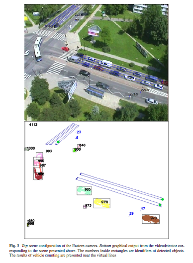
What differentiates INSIGMA from other systems is the use of video detection and GPS positioning to gather information about the current traffic.
The INSIGMA system is based on three main data-oriented: the
Static Map, the Dynamic Map and the Dynamic
Map Warehouse They handle slow-changing, fast-changing and historical data
related respectively to the transport infrastructure. The slow-changing data
regards road infrastructure, including details like roads, junctions, lanes,
traffic signs, and road accessibility. The accessibility parameter indicates
whether particular roads are available for specific users, such as regular or
emergency vehicles. An emergency vehicle, for instance, is allowed to use a
sidewalk, while a regular vehicle is not.
The fast-changing data regard dynamic parameters, so-called
monitoring parameters, which represent the current or recent traffic conditions
and events, including threat reporting or detection. The historical data regard
aggregated fast-changing data with relationships to the slow-changing data
objects. Separating it from the dynamic parameters provides means to conduct
time-based analysis offloading the Dynamic
Map.
Data gathered by these three data storesare accessible
through web service-based interfaces: IMS
(INSIGMA-Map-Static) Interface, IMD
(INSIGMA-Map-Dynamic) Interface, and IHD
(INSIGMA-wareHouse-Dynamic) Interface.
A Dynamic Map system
running at full throughput, handling 5 metropolitan areas and acquiring data
from 11,250 sensors, generates a data growth rate of 500 facts per second.
Assuming approximately 100 bytes per fact, the data volume is 28GB per week.
Such a growth rate would overload the Dynamic
Map by slowing down or crippling its processing capabilities. To prevent
that, historical facts are transferred into the Dynamic Map Ware- house.
In the INSIGMA system, privacy is related to both video and
GPS/GLONASS tracking. Each digital image from the camera can contain sensitive
data, taking into account the privacy of registered persons or vehicles.
Special attention is paid to the protection of images of faces, license plates
and other information that can be used to identify identities.
4 Conclusions
The paper presents the contribution of the INSIGMA project
to the Intelligent Transportation System (ITS) domain. The proposed tools and
components provide functions and services related to traveler information,
traffic management and emergency transportation operations. They are built
around the Dynamic Map concept, a repository which gathers dynamically changing
and constantly updating traffic and event-oriented information.
The information gathered by the Dynamic Map comes from
several sensors deployed in an urban area including but not limited to: video
detectors and GPS trackers. Several services are also provided. These include
route planning and traffic lights opti- misation as well as traffic management.
The researchers conclude that, compared with other ITS, the
proposed system provides a comprehensive, integrated source of traffic related
information. It is capable of being easily extended with a range of diverse
sensors. Furthermore, it is applicable to urban areas where centralized and
global route planning services tailored for specific users provide the greatest
impact.
From a variety of functions which can be provided by an ITS,
the system developed within the INSIGMA project supports: traveler information, including route planning, on-trip traffic
information and route guidance, as well as traffic
management (transportation planning and traffic control).
The paper stresses that the key concept within the system is the Dynamic Map, which integrates the description of a road network with dynamically- changing traffic information.
Within the project, advanced algorithms for dynamic route
planning and traffic control have been developed. It is expected that their
application in real life will significantly improve mobility and environmental
performance.
Authors: Timo Möler, Asutosh Padhi, Dickon Pinner and Andreas Tschiesner, all members of the McKinsey Center for Future Mobility published an article in McKinsey & Company in December 2019, named “The future of mobility is at our doorstep”.
The article provides an up to date review on this issue. Here there are some of the key issues.
The past year was a pivotal one, with many important achievements across the disruptive dimensions of mobility: autonomous driving, connectivity, electrification and shared mobility (ACES). In 2019, electric-vehicle (EV) sales set another sales record global. Some players demonstrated truly driverless cars without backup drivers, setting new milestones in autonomous driving. Uber and Lyft – the two big disruptors in the ride-hailing space – went public in spring 2019. Also in 2019, regulators began granting approval to drone deliveries and to electric vertical takeoff and landing crafts, with these types of vehicles flying for the first time.
The article stresses that 2019 was also a year of reality checks, as congestion and public – transportation woes reached new heights for cities around the world, realization timelines for technology like autonomous vehicles (AVs) were postponed, and some new mobility business models failed to win over investors.
Authors point out that key risks for the industry remain elevated and that competition from new mobility attackers is intensifying, the road ahead remains bumpy, as today’s reality delivers a mixed picture for the future of mobility. On the one hand, there are big expectations with regard to future technologies and business models; on the other hand, there is an urgent need for a “double transformation”. In other words, preparing companies for the mobility of tomorrow also means making today’s business crisis resistant.
Investments across the mobility landscape
The authors remark a continued acceleration of investments in the relevant technologies – with e-hailing, semiconductors, and sensors for advanced driving – assistance systems and autonomous driving still being the front-runners.
On a regional level, activity in the United States is strongest,
but tech-intense locations, such as Israel, also play important roles in the
mobility ecosystem.
Autonomous driving
2019 was a year
in which optimistic forecasts had to be scaled back to a certain degree. And the automotive industry is
quickly turning into a true mobility ecosystem.
Yet the underlying logic for autonomous driving, especially in cities, remains intact. The article highlights that electric, shared AVs – also called robo-taxis or -shuttles – could address mobility’s pain points in cities (such as road congestion, crowded parking spaces, and pollution) while revolutionizing urban mobility, making it more affordable, efficient, user friendly, environment friendly, and available to everyone.
Of the global markets for AVs, China catches the eye. It
has the potential to become the world’s largest market for AVs.
Connectivity
Connected cars are poised to become
potent information platforms that not only provide better experiences for
drivers but also open new avenues for businesses to create value. According to
the authors, the key success factor for connectivity services is the clear value
proposition the offering has, either to an external customer or to an internal
stakeholder.
Electrification
While the signals are somewhat mixed for autonomous technology, the “E” in ACES – electrification – certainly gained momentum in 2019. This development was triggered by two trends: tightening regulation – for example, in Europe – and rising customer demand.
The challenge of making EVs profitable remains, but OEMs
and their suppliers are working hard to address it successfully.
Advancements in battery technology, economies of scale in EV production, native EV design, and cooperation among OEMs can help bring down costs – which are currently still higher than for comparable internal – combustion – engine (ICE) vehicles.
Shared mobility
In this respect, 2019 certainly has been the year of many
cities’ announcements of their future mobility visions, including micro
mobility. With micro mobility being a nascent market in Europe, many
start-ups introduced shared e-scooters in European cities.
The 2020 outlook
Consumers. As CO2
regulations in Europe kick in next year and more EVs need to be pushed onto the
road, 2020 will be an important year to measure the reinforcing power of
electrification. Early adopters love their EVs, but will followers as well?
Technology. Might 2020 be
the year in which more attention is given to the transport of goods? The
commercial-mobility segment could catalyze some noteworthy developments. One
example here is autonomous driving in the context of shared mobility.
Specifically, the replacement of the driver cost is a significant element of
the total cost of ownership.
Market and competition. The
authors understand that 2020 will be characterized as the year of the
intensifying “double mobility transformation,” with players operating in an
economic slowdown but, at the same time, needing to rethink their business
models in a time of heightened city regulation, technology disruptions, and
changing consumer needs.
The growing role of
regulation. For many players and for many technologies, cities will be the most
important stakeholders. From “sticks” (such as parking fees, low- or
no-emission zones, and city tolls) to “carrots” (such as piloting new robo-taxi
or -shuttle service-mobility solutions), it will be cities where the future of mobility
will be decided.
ICBC is taking the next step into telematics research with a one-year pilot project to see if technology can improve driving and make B.C. roads safer.
Drivers can sign-up today to join the pilot which starts in November. If you have less than four years driving experience, either in the novice stage of the Graduated Licensing Program or with your full license, you’re eligible to join.
We’re always looking for interesting ideas and content to share within our community.
Get in touch and send your proposal to: press@octotelematics.com
Your privacy
This site uses cookies or similar technologies of a technical nature, including from third parties (to allow the website to function correctly and smoothly), and, with your consent, also profiling (to send advertising messages in line with your preferences expressed in the context of web browsing and/or to analyze the behavior of visitors to the site), as specified in the Cookie policy. You can manage your preferences using the 'Cookies Settings' button. We remind you that clicking on 'Reject all cookies' or closing the banner using the appropriate X, involves the persistence of default settings, and therefore you will continue to navigate in the absence of cookies other than technical ones.
Privacy Preference Center
General information
When you visit any website, it may store information on your browser, mostly in the form of cookies. This information might be about the site navigation, your preferences or data relating to the device used. Some of these cookies are used to provide you with a better browsing experience and allow you some features (Navigation or session cookies, Functionality cookies, Analytics cookies), others to send you personalized advertisements (Profiling cookies). You can choose not to allow the installation of cookies - net of the technical ones necessary for the functioning of the Site - by clicking on the headings of the relevant categories to find out more and change the settings using the "ACTIVE/INACTIVE" slider. However, disabling certain types of cookies may limit your browsing experience on the Site and the services we can offer. Octo informs users that the different types of cookies used have a persistent duration until the cookie configuration settings are changed.
Technical Cookies
Always on
The technical cookies used by Octo are necessary for the functioning of this Site. This type of cookie is used in response to user requests for services, such as authentication to access restricted areas or filling in forms. These cookies ensure the normal navigation and use of the Site. You can set the browser used for navigation to block these cookies, but some sections of the Site may not work.
Octo telematics
pll_language - www.octotelematics.com
The cookie stores the language code of the last page visited. (duration: 1 year)
PHPSESSID - www.octotelematics.com
The cookie is used to store and identify a user's unique session ID for the purpose of managing the user's session on the website. The cookie is a session cookie and is deleted when you close all browser windows. (duration: Session)
YouTube
VISITOR_INFO1_LIVE - *.youtube.com
Used to track the information of YouTube videos embedded on a website. (duration: 5 months and 27 days)
CONSENT - *.youtube.com
(duration: 16 year and 8 months)
YSC - *.youtube.com
It is used to track the views of embedded videos. (duration: Session)
Analytics Cookies
Octo uses analytics services to understand the level of effectiveness of the content, the interests of users and to improve the functioning of this Site.
Google
test_cookie - *.doubleclick.net
The purpose of the cookie is to determine whether the user's browser supports cookies. (duration: 15 minutes)
IDE - *.doubleclick.net
It stores information about how the user uses the website and any other advertisements before visiting the website. It is used to present users with advertisements that are relevant to them based on their user profile. (duration: 1 year and 24 days)
Profiling Cookies
This Site uses Profiling cookies to send targeted advertising to users, that is in line with their preferences expressed during navigation. In particular, these types of cookies are installed by third parties, advertising partners of Octo Telematics S.p.A. who may present, also on other sites, ads and advertising content based on the interests shown. The installation and use of these cookies requires the user's consent.
Facebook
_fbp - *.facebook.com
It is used to deliver advertisements when they are on Facebook or on a digital platform powered by Facebook advertising after visiting this website. (duration: 90 days)
fr - *.facebook.com
It is used to show relevant ads to users and measure and improve ads. The cookie also tracks user behavior across the web on sites that have Facebook pixels or Facebook social plugins. (duration: 90 days)
datr - *.facebook.com
The purpose of the cookie is to identify the web browser used to connect to Facebook regardless of the user who is logged in. This cookie plays a key role in the security and integrity features of the Facebook site. (duration: 2 years)
LinkedIn
lang - ads.linkedin.com
This cookie is used to store a user's language preferences to offer content in that stored language the next time the user visits the website. (duration: Session)
bcookie - *.linkedin.com
The purpose of the cookie is to enable LinkedIn features on the page. (duration: 2 years)
bscookie - www.linkedin.com
This cookie is a browser cookie ID set by the linked share buttons and advertisements tags. (duration: 2 years)
lidc - *.linkedin.com
Used for routing. (duration: 1 day)
li_gc - *.linkedin.com
Used to store the consent of users of the Site regarding the use of cookies other than technical ones. (duration: 2 years)
UserMatchHistory - *.linkedin.com
Used for LinkedIn Ads ID synchronization. (duration: 30 days)
AnalyticsSyncHistory - *.linkedin.com
Used to store information about the time when a synchronization with the lms_analytics cookie took place for users in the designated countries. (duration: 30 days)
Vimeo
vuid - *.vimeo.com
This cookie is used by Vimeo to collect tracking information. It sets a unique ID to embed videos in your website. (duration: 2 years)